
ATTENTION! TOUTES LES FONCTIONS NE SONT PAS DISPONIBLES DANS LES EMAILS. UTILISEZ PLUTÔT LA VERSION NAVIGATEUR: http://nbbc-met.blogspot.fr/. WARNING, ALL FUNCTIONS NOT AVAILABLE IN EMAIL... INSTEAD, USE THE BROWSER VERSION: http://nbbc-met.blogspot.fr/
National Hurricane Center via Wunderground
 | Nouvelle Onde Tropicale |
Détails... plus bas, après les webcams.
 | New tropical Wave |
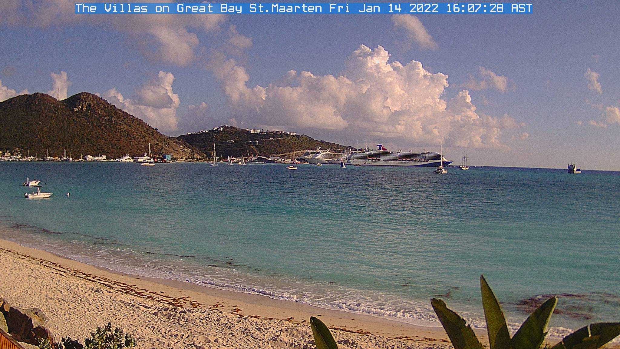
| Webcams St Martin-St Barts | ||
 |
|
 |
| Nettle Bay Beach Club, netcam3, anse 3 | Nettle Bay Beach Club. Netcam1, anse 3 | Nettle Bay Beach Club, netcam2 (anse 4) |
 |
 |
|
| Philpsburg, Great Bay | St Barts, Gustavia | Baie St Jean, St Baths |
| LA METEO DE BAIE NETTLÉ |
- ALERTES: RIEN NE MENACE NOS ÎLES.
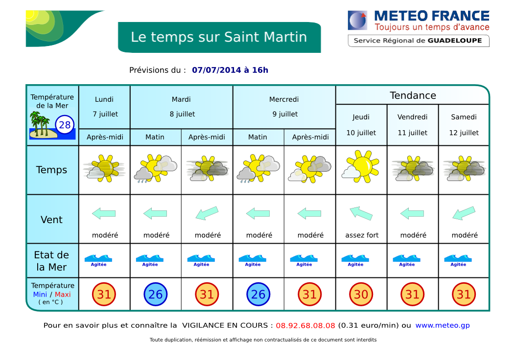
- DERNIÈRES 24 H: quelques courtes et légères averses isolées, temps plutôt beau. ACTUELLEMENT: plutôt beau mais quelques petites averses éparses de temps en temps. Partiellement ensoleillé à parfois très nuageux. Vent d'est modéré. Dans la baie: mer assez agitée. AUJOURD'HUI / NUIT PROCHAINE: partiellement ensoleillé devenant très nuageux à couvert l'après-midi et la nuit prochaine avec de fortes chances d'averses modérées à parfois fortes. ORAGES: quelques uns possibles. DEMAIN: encore des averses isolées possibles, peut-être des orages, amélioration progressive ensuite. Voir SATELLITES.
- TENDANCE: amélioration probable à partir de jeudi. Nouvelle dégradation due à une nouvelle Onde Tropicale aux alentours du weekend.
- VENTS: Peu de changements. Alizés d'est modérés à assez forts avec de fortes rafales possibles en avant des grains. MER: peu agité à agitée sous les rafales en Baie de Marigot. Très agitée à parfois forte au large. Température de l'eau 27 à 28º C environ. HOULE: d'Est modérée non gênante en Baie de Marigot. VISIBILITÉ: faible sous averse. Faible brume de sable mais elle devrait s'intensifier prochainement.
- DONNÉES: vent d'est 10-15 noeuds, 18-28 kmh, 25 nd possibles sous rafales. Mer 1.2 à 2.4 m possible en Atlantique. Houle modérée d'Est environ 2 m, 8 secondes (pas de changement). Plus de détails.
- CYCLONES: Rien en vue. Une nouvelle onde tropicale devrait arriver dans 4-5 jours. Voir NHC

- FRANCE: peu de changements. Le temps restera globalement calme et sec sur la France, mais toujours un peu frais pour un début d'été... en savoir plus: Meteo France. QUEBEC: chaud et orageux: meteomedia
- NAVIRES: Galisbay: Midnight Tide ("Marée de Minuit"), mini-cargo, et Ocean Princess, tanker, tous deux des habitués. Philipsburg: STEEL, charter yacht de 55 m.

Midnight Tide
| BAIE NETTLÉ FORECAST |
- WATCH OR WARNING: NO THREAT TO OUR ISLANDS.
- WEATHER... LAST 24 HR: yesterday, partly sunny to cloudy skies with a few light to moderate showers. CURRENTLY: fairly fine weather with however some scattered light showers here and there. TODAY / TONIGHT: A Tropical Wave arriving. Partly sunny to cloudy becoming cloudier with high chance of showers in the afternoon and tonight, possibly a few thunderstorms. TOMORROW: chance of rain and thunder maybe. Slight improvement expected in the second part of Wednesday. TREND: some improvement is likely in the next few days. However, expect a new Tropical Wave around Saturday or Sunday. SATELLITES.
- THUNDERSTORMS: few.
- WINDS: moderate to fresh easterly tradewinds with higher gusts possible in showers. SEAS: Slight to possibly choppy in the Bay, choppy to rough over open waters. Water temperature 80.6 to 82.4º F. SWELL: From east, Insignificant here. VISIBILITY: poor in showers. Weak sand dust haze, increasing.
- DATA: Winds: easterly, 12-25 Mph. Seas: 4 to 6-7-8 ft. Swells: easterly 6-7 ft, 8 seconds. More data....
-
TROPICAL CYCLONE: No tropical cyclone at this time. The Atlantic remains tranquil. New Tropical wave will arrive from Saturday. NHC
- USA: ... risk of severe thunderstorms Tuesday afternoon and evening from the northern Plains across the Upper Midwest and Ohio Valley and into the Northeast and New England... more: www.weather.gov. CANADA: Extreme Weather Pattern starting this Weekend. See accuweather.com/en/weather-video (English).
- SHIPS: Galisbay harbor: Ocean Princess, tanker and Midnight Tide, coaster. Philipsburg: Steel, 180 ft motor yacht.

Steel
AIDE- INFO - HELP
Image Satellite Infra-rouge Petites Antilles. Ne s'affiche pas dans certains emails. Ce n'est plus une animation mais une image fixe de manière à alléger la page.
Lesser Antilles infrared loop. Does not appear in some emails. It is no longer a loop but a still image to lighten the page..
Image Satellite Infra-rouge Petites Antilles. animation en pop-up - Lesser Antilles infrared image. loop in pop-up.
| . |
ORAGES - THUNDERSTORMS
Zoom - St Martin: point rouge - red dot (rafraîchissement toutes le 5 mn - refreshes every 5 mn)
Prévisions graphiques - Meteo France - Graphic forecast
