lundi 15 juillet 2013

126 - Assez beau temps, mais...
Rather fine weather, but...

...des nuages par moments avec de bonnes chances d'averses isolées ... passing clouds with good chance of isolated showers


ATTENTION! TOUTES LES FONCTIONS NE SONT PAS DISPONIBLES DANS LES EMAILS. UTILISEZ PLUTÔT LA VERSION NAVIGATEUR: http://nbbc-met.blogspot.fr/. WARNING, ALL FUNCTIONS NOT AVAILABLE IN EMAIL... INSTEAD, USE THE BROWSER VERSION: http://nbbc-met.blogspot.fr/

NO TROPICAL CYCLONE AT THIS TIME - AUCUN CYCLONE ACTUELLEMENT

National Hurricane Center via Wunderground


DÉGRADATION PROBABLE
Temps relativement clément aujourd'hui avec tout de même un risque d'averses isolées comme hier. Une Onde Tropicale et sa perturbation, pour  l'instant peu active, va arriver dans les prochaines 36 h sur les Petites Antilles et apportera probablement un temps nuageux et pluvieux. Une seconde Onde Tropicale la suivra 24-36 h plus tard. Elle sera peut-être plus active. Vents d'est faibles à modérés devenant modérés à assez forts au passage de l'Onde. En Caraïbes : mer peu agitée, creux de 0.6 à 1m, devenant agitée avec des creux de 1,5m. En Atlantique : agitée, ceux moyens de 1,50m devenant très agitée 1.8 m. Mercredi, la mer pourrait être forte 2.5 m en Atlantique.
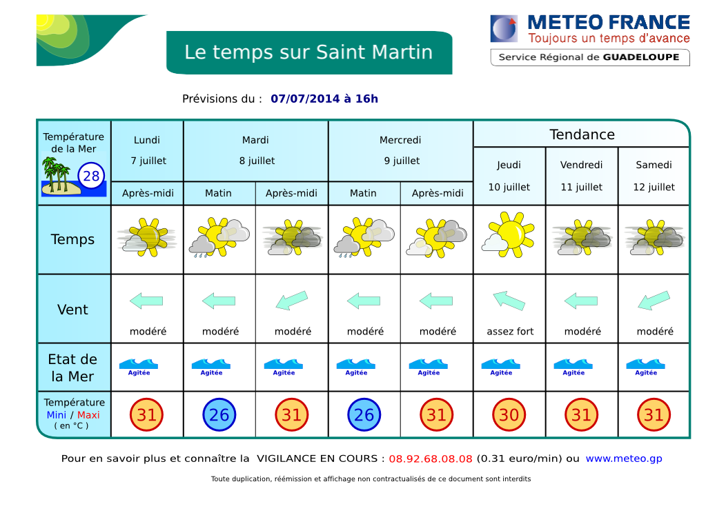
RIEN NE MENACE NOS ÎLES.

Plus de détails dans le prochain bulletin en cours de journée...

WORSENING LIKELY
Relatively fine weather today with still a chance of isolated showers like yesterday. A Tropical Wave and its disturbance, weak at this time, will arrive in the next 36 hours over Lesser Antilles and probably bring cloudy and rainy weather. A second wave will follow 24-36 h later. It may be more active. Winds are low to moderate becoming moderate to relatively strong during the passage of the wave. In Caribbean Sea, slight seas 2-3 ft. Over Atlantic waters: moderate 5 ft becoming choppy 5-6 ft  and even rough on Wednesday.
NO THREAT TO OUR ISLANDS

More details... Full forecast bellow, after the webcams..


Prévisions météo graphiques du NHC (cliquez sur l'image pour l'agrandir)
NHC Graphicast, graphic forecast (Click image to enlarge)


Webcams St Martin-St Barts


Nettle Bay Beach Club, netcam3, anse 3 Nettle Bay Beach Club. Netcam1, anse 3 Nettle Bay Beach Club, netcam2 (anse 4)


Philpsburg, Great Bay St Barts, Gustavia Baie St Jean, St Baths
La webcam de Philipsburg peut afficher une mise en garde. Si c'est le cas, allez la voir sur ce site: http://www.kroooz-cams.com/portcams/caribbean/st_maarten.php


Image Satellite Infra-rouge Petites Antilles. Ne s'affiche pas dans certains emails. Ce n'est plus une animation mais une image fixe de manière à alléger la page. Cliquez ici pour voir l'animation dans un pop-up. Lesser Antilles infrared loop. Does not appear in some emails. It is no longer a loop but a still image to lighten the page.. Click here to see the loop in pop-up. 

Image Satellite Infra-rouge Petites Antilles. animation en pop-up - Lesser Antilles infrared image. loop in pop-up. 
.


ORAGES - THUNDERSTORMS
Zoom - St Martin: point rouge - red dot (rafraîchissement toutes le 5 mn - refreshes every 5 mn)

Prévisions graphiques - Meteo France - Graphic forecast

logo nbbc Nettle Bay Beach Club - St Martin Island - FWI


Afficher le blog