National Hurricane Center via Wunderground
| Température Mer - Sea temperature (Baie Nettlé) | ||
≥ 27º C
|
à
|
< 28º C
|
≥ 80º6 F
|
to
|
< 82º4 F
|

| LA METEO DE BAIE NETTLÉ |
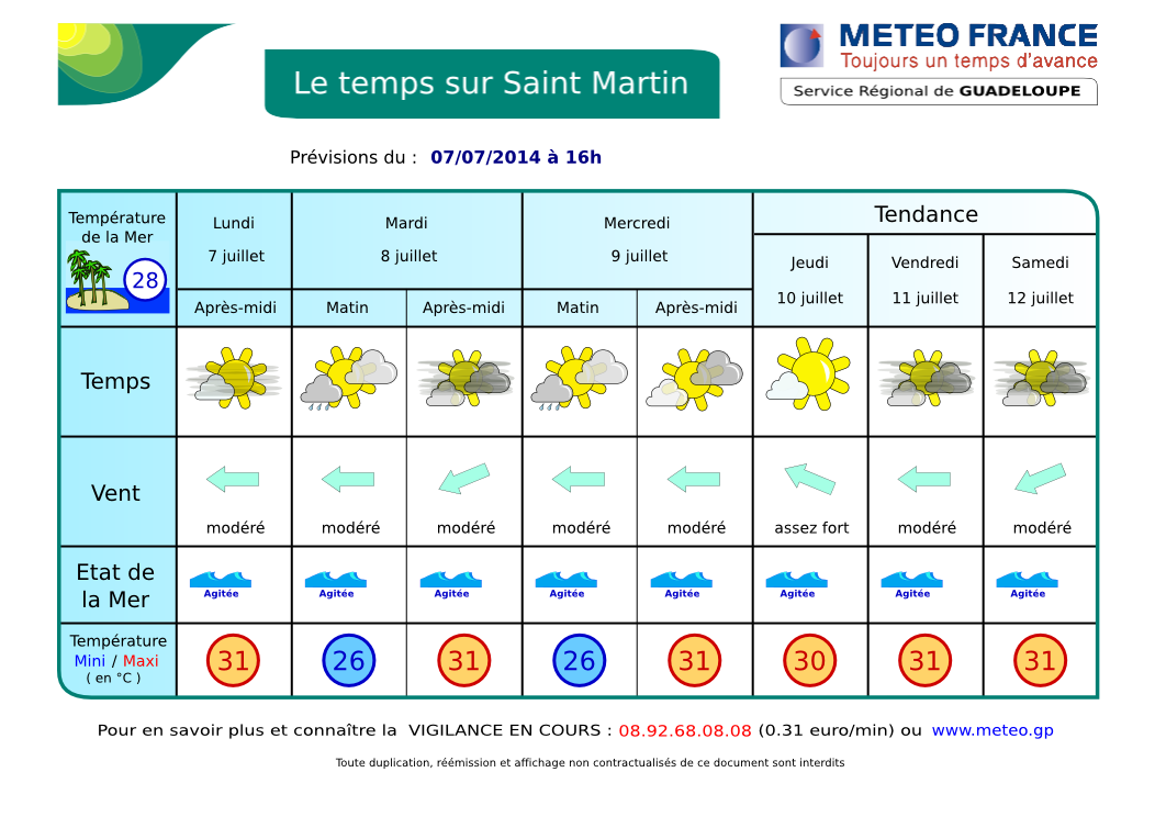
- RÉSUMÉ: Pour au moins les quelques jours à venir, les hautes pressions vont maintenir des conditions relativement stables avec de rares averses. Quelques poches d'humidité en relation avec une onde tropicale passant plus au sud pourraient cependant encore produire quelques averses d'intensité faible à modérée. Par ailleurs, les vents seront généralement modérés avec des conditions de mer tranquilles une bonne partie de la semaine. (d'après www.meteo.an)
- DERNIÈRES 24 H: hier, quelques averses, ciel souvent nuageux, vents soutenus. ACTUELLEMENT: Belles éclaircies mais pas mal de nuages. Vents soutenus d'est. AUJOURD'HUI / NUIT PROCHAINE: Ce matin, partiellement ensoleillé à souvent nuageux devenant plus nuageux dans l'après-midi et ce soir. Averses possibles. Voir SATELLITES.
- TENDANCE: jours suivants, peu de changements. Possible dégradation en fin de semaine avec une autre Onde Tropicale. Celle-ci devrait cependant passer plus au sud.
- VENTS: Peu de changements. Alizés d'est modérés à assez forts avec de fortes rafales possibles en avant des grains. MER: peu agité à agitée en Baie de Marigot. Très agitée à parfois forte au large. HOULE: d'Est non gênante ici. VISIBILITÉ: faible sous averse. Retour de la brume de sable.
- CYCLONES: Rien à craindre pour notre région. Une onde tropicale passe actuellement plus au sud. Une autre onde est en route et devrait toucher les Petites Antilles dans 4-5 jours.
- NAVIRES: 2 caboteurs à Galisbay: Muttys Pride et Midnight Wolf
Midnight Wolf

AIDE- INFO - HELP
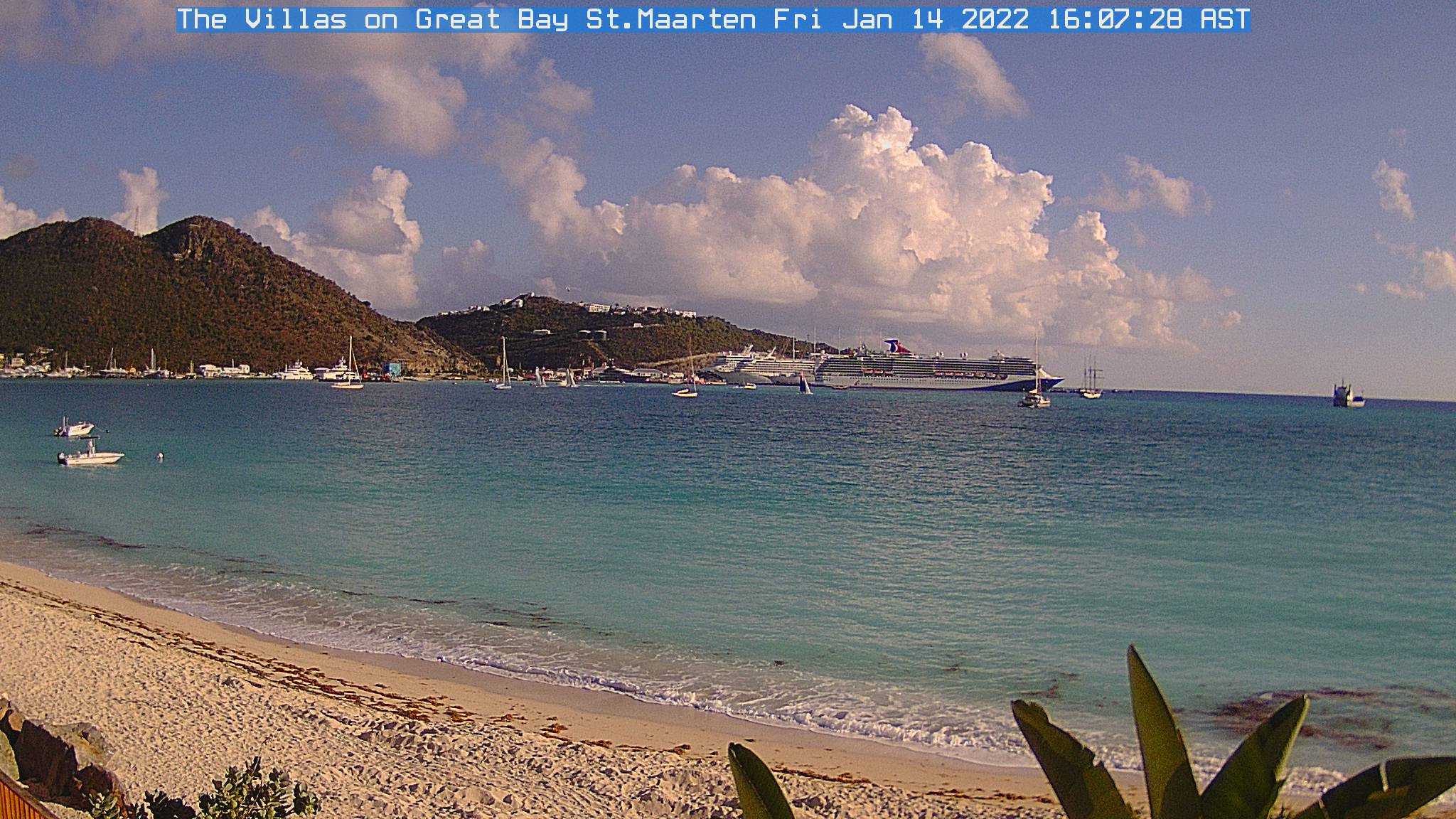
| Webcams St Martin-St Barts | ||
 |
|
 |
| Nettle Bay Beach Club, netcam3, anse 3 | Nettle Bay Beach Club. Netcam1, anse 3 | Nettle Bay Beach Club, netcam2 (anse 4) |
 |
 |
|
| Philpsburg, Great Bay | St Barts, Gustavia | Baie St Jean, St Baths |
 |
NETTLE BAY FORECAST |
- SYNOPSIS: For at least the next few days a surface high pressure will maintain a stable atmospheric condition with limited shower activity across the area. Some patches of moisture, related to a tropical wave moving west with most activity south of the region, could still induce a few showers of light to moderate intensity. Otherwise, winds will be generally moderate with a fairly tranquil marine condition through much of the current week.. (based www.meteo.an)
- LAST 24 hours: yesterday, partly to mostly cloudy skies with few showers. CURRENTLY: partly sunny to cloudy. Moderate winds. TODAY / TONIGHT: becoming cloudier in the afternoon and tonight with a chance of shower. TREND: Little change. New worsening possible at the end of the week with another Tropical Wave. However, it should remain further south. See SATELLITES.
- WINDS: moderate to relatively strong easterly winds 12-25 Mph with higher gusts possible in showers. SEAS: Slight to possibly choppy in the Bay, choppy to rough on open waters. SWELL: Insignificant here. VISIBILITY: poor in showers. Sand dust haze is back.
- TROPICAL CYCLONE: No tropical cyclone at this time. A Tropical wave crossing over Windwards. Another Tropical Wave will arrive on Windward Islands at the end of the current week.
- SHIPS: 2 coasters at Galisbay: Muttys Pride and Midnight Wolf
Muttys Pride


Animation Satellite Infra-rouge Petites Antilles. Ne s'affiche pas dans certains emails. Cliquez ici pour la voir dans un pop-up. Lesser Antilles infrared loop. Not visible in some emails. Click here to see it in pop-up.
Animation Satellite Infra-rouge Petites Antilles - Lesser Antilles infrared loop
| . |
ORAGES - THUNDERSTORMS
Zoom - St Martin: point rouge - red dot (rafraîchissement toutes le 5 mn - refreshes every 5 mn)