ATTENTION! TOUTES LES FONCTIONS NE SONT PAS DISPONIBLES DANS LES EMAILS. UTILISEZ PLUTÔT LA VERSION NAVIGATEUR: http://nbbc-met.blogspot.fr/. WARNING, ALL FUNCTIONS NOT AVAILABLE IN EMAIL... INSTEAD, USE THE BROWSER VERSION: http://nbbc-met.blogspot.fr/

National Hurricane Center (NHC). Vérifiez bien les dates! Check dates!
Le nombre de messages affiché ici est limité à 1. Voir ici les autres "Tweets".
National Hurricane Center via Wunderground
| Température Mer - Sea temperature (Baie Nettlé) | ||
≥ 27º C
|
à
|
< 28º C
|
≥ 80º6 F
|
to
|
< 82º4 F
|
 |
LA METEO DE BAIE NETTLÉ |
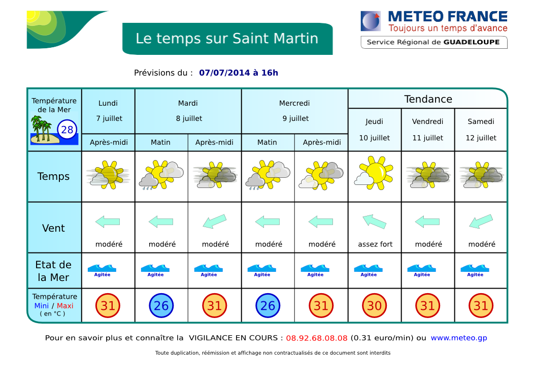
RÉSUMÉ: Pour aujourd'hui, on attend un temps généralement beau avec quelques averses insignifiantes. Le Brume de poussière du Sahara continuera de régner sur la région jusqu'en milieu de semaine. Le temps est prévu de se dégrader la nuit prochaine ou tôt mercredi matin jusqu'à jeudi matin au passage d'une nouvelle onde tropicale et de sa perturbation. Dans le sillage de l'onde, une masse d'air plus sèche et stable sera à nouveau en place jeudi, mais cela ne devrait pas durer plus de 36 h.
- DERNIÈRES 24 H: hier, quelques courtes et légères averses... Impression de ciel couvert due principalement à la brume de poussière saharienne. ACTUELLEMENT: partiellement ensoleillé à parfois plus nuageux avec un faible risque d'averses isolées. La brume de sable reste assez intense. AUJOURD'HUI: le ciel devrait devenir plus nuageux cet après-midi et la nuit prochaine avec un risque accru d'averses et peut-être d'orages. DEMAIN: temps médiocre jusqu'à jeudi matin. Voir les images SATELLITES.
- TENDANCE: Jeudi, amélioration possible mais de courte durée.... Vendredi et samedi, temps variable avec des averses possibles. Nouvelle dégradation à partir de dimanche due à une nouvelle Onde Tropicale ....
- VENTS: Peu de changements. Alizés d'est modérés à assez forts avec de fortes rafales possibles en avant des grains. MER: peu agité à agitée en Baie de Marigot. Très agitée à parfois forte au large. HOULE: d'Est se renforçant un peu, non gênante ici. VISIBILITÉ: faible sous averse. Pas mal de brume de sable.
- CYCLONES: La Dépression Tropicale nº 2 aborde le Guatemala en donnant de fortes pluies sur cette région. Voir NHC
 . Une onde tropicale devrait arriver cette nuit. Une autre onde devrait arriver dans environ 5 jours. RIEN NE MENACE SERIEUSEMENT NOS ÎLES.
 - FRANCE: Meteo France. Orages et chaleur. QUEBEC: meteomedia
- NAVIRES: Midnight Tide, Midnight Wolf, Midnight River et Muttys Pride sont des mini-cargos inter-îles. Ils peuvent aussi servir à remorquer des barges sans moteur. Ils ravitaillent les îles en général à partir de Porto-Rico. Midnight River appareille actuellement pour Tortola. Paquebot Disney Fantasy à Philipsburg.

Disney Fantasy à Philipsburg
INFO: Vents: 20 à 50 kmh, rafales sous grains 50 à 75 kmh possible. Mer 1.8 à 2.10 m, possible 2.4 m et plus.. Houle d'est 2.10 m, 9 secondes.
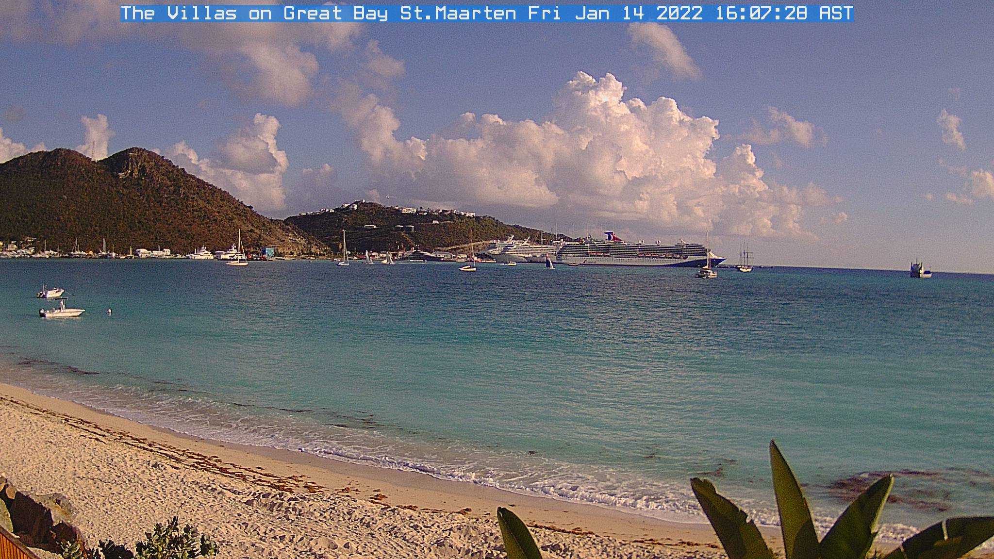
| Webcams St Martin-St Barts | ||
 |
|
 |
| Nettle Bay Beach Club, netcam3, anse 3 | Nettle Bay Beach Club. Netcam1, anse 3 | Nettle Bay Beach Club, netcam2 (anse 4) |
 |
 |
|
| Philpsburg, Great Bay | St Barts, Gustavia | Baie St Jean, St Baths |
 |
NETTLE BAY FORECAST |
SYNOPSIS: A generally fair weather with a few insignificant showers is expected to prevail through today. The Saharan Dust Haze will also continue across the area for sometime through midweek. Weather condition is foreseen to change tonight and early on Wednesday morning throughout the early parts of Thursday as a tropical wave and its related inclement weather will move over our region. In wake of the wave a relatively drier and stable airmass will again establish on Thursday but it should not last more 36 h. (partly inspired from meteo.an)
- LAST 24 HRS. Yesterday, a few short light showers. Fairly fine weather... Feel of overcasted skies mainly due to the Saharan dust haze. CURRENTLY: partly cloudy to cloudier at times with a low chance of a isolated shower. Sand haze is pretty intense. TODAY: Skies should become mostly cloudy in the afternoon and tonight with an increased risk of showers and possibly thunderstorms. TOMORROW: poor weather until Thursday morning. See SATELLITES. THUNDERSTORMS: None at this time.
- WINDS: moderate to relatively strong easterly winds with higher gusts possible in showers. SEAS: Slight to possibly choppy in the Bay, choppy to rough over open waters. SWELL: From east (increasing), Insignificant here. VISIBILITY: poor in showers. Lot of sand dust haze.
-
TROPICAL CYCLONE: No tropical cyclone at this time but Tropical Depression #2 hit Guatemala with heavy downpour. New Tropical wave arriving as of tonight or early morning. Another Wave will arrive within about 5 days. NO SERIOUS THREAT TO OUR ISLANDS. See NHC
- USA: see www.weather.gov. CANADA: see accuweather.com (English)
- SHIPS: Midnight Tide, Midnight Wolf, Midnight River Muttys Pride are inter-island mini-cargos. They can also tow barges. They resupply the islands in general from Puerto Rico. Midnight River just leaved Galisbay and enroute to Tortola. Disney Fantasy cruise ship mooring in Philipsburg.

Midnight Wolf
AIDE- INFO - HELP

Animation Satellite Infra-rouge Petites Antilles. Ne s'affiche pas dans certains emails. Cliquez ici pour la voir dans un pop-up. Lesser Antilles infrared loop. Not visible in some emails. Click here to see it in pop-up.
Animation Satellite Infra-rouge Petites Antilles - Lesser Antilles infrared loop
| . |
ORAGES - THUNDERSTORMS
Zoom - St Martin: point rouge - red dot (rafraîchissement toutes le 5 mn - refreshes every 5 mn)
Prévisions graphiques - Meteo France - Graphic forecast