|  |
 | |

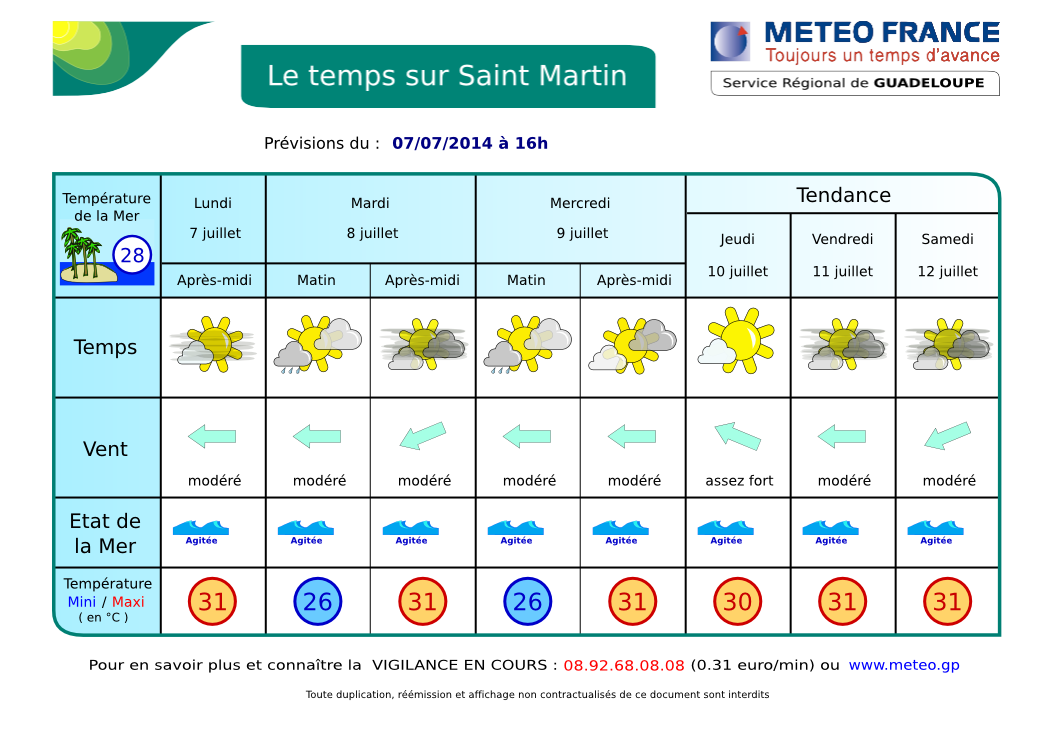
RÉSUMÉ: NOUS SOMMES EN VIGILANCE JAUNE tout comme la Guadeloupe et la Martinique pour fortes pluies et orages. Une zone perturbée stagnant plus ou moins sur les Petites Antilles apporte un temps instable et orageux. Cet épisode avait bien été prévu par les prévisionnistes mais pour ce matin. Le mauvais temps est arrivé en fait vers 13 h avec des pluies soutenues et quelques coups de tonnerre. Une accalmie est apparue vers 17 h. Cette amélioration est juste temporaire et il faut s'attendre à d'autres averses et orages dans les prochaines 12 heures au moins. DEMAIN matin: chances de pluies et ORAGES. Probablement quelques accalmies en cours de journée. Voir SATELLITES. TENDANCE: jours suivants, même type de temps sauf si la masse nuageuse finit par s'éloigner ou se dissiper. VENTS: Les Alizés d'est restent modérés à assez forts par moments avec de fortes rafales possibles sous les grains, s'améliorant un peu à partir de jeudi ou vendredi. MER: peu agité à agitée dans la baie. Très agitée à parfois forte au large, jusqu'à 2.5 m possible. HOULE: d'Est faible à modérée. VISIBILITÉ: très réduite sous averse, bonne autrement. CYCLONES: Rien à signaler dans le bassin Atlantique.
AIDE- INFO - HELP
| |||||||||||||||||


SYNOPSIS: YELLOW WATCH just like Guadeloupe and Martinique. A disturbed area staying over the region provides an unstable and stormy weather. This episode had been expected by forecasters but earlier this morning. In fact, this bad weather arrived at 13 h with sustained rainfall and some thunder. A lull appeared around 17 h. This improvement is just temporary and we can expect other showers and THUNDERSTORMS in the coming 12 hours at least.. TOMORROW morning: chance of rain and THUNDERSTORMS. See SATELLITES.
WINDS: moderate to relatively strong easterly winds 12-25 Mph with higher gusts possible in showers. Some improvement possible from Thursday. SEAS: Slight to possibly choppy in the bay, choppy to locally rough at sea, possible 8 ft. SWELL: light from east. VISIBILITY: poor in showers. TREND: in the following days, little change expected with some tranquil periods here and there, unless this cloudy area will shift away or dissipate. TROPICAL CYCLONE: No tropical cyclone at this time over Atlantic Basin.
AIDE- INFO - HELP
Animation Satellite Infra-rouge Petites Antilles. Ne s'affiche pas dans certains emails. Cliquez ici pour la voir dans un pop-up. Lesser Antilles infrared loop. Not visible in some emails. Click here to see it in pop-up.
Animation Satellite Infra-rouge Petites Antilles - Lesser Antilles infrared loop
| . |